Bolivia
Country statistics
Land area: 418,683 sq miles (1,084,389 sq km)
Total area: 424,164 sq miles (1,098,580 sq km)
Population (2012 est.): 9,947,418 (growth rate: 1.7%); birth rate: 25.1/1000; infant mortality rate: 43.4/1000; life expectancy: 67.2; density per sq km: 8
Capital City: Sucre, La Paz (Administrative capital)
Monetary unit: Boliviano
Languages: Spanish, Quechua, Aymara (all official)
Ethnicity/race: Quechua 30%, mestizo 30%, Aymara 25%, white 15%
Religions: Roman Catholic 95%, Protestant (Evangelical Methodist) 5%
Country introduction
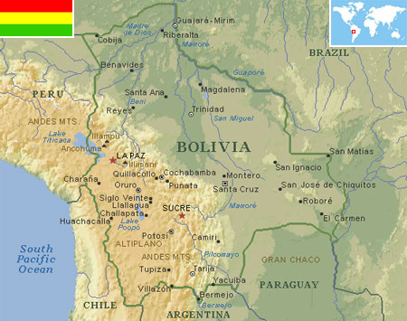
Bolivia is a landlocked country in central South America. It is bordered by Brazil to the north and east, Paraguay and Argentina to the south, Chile to the south-west, and Peru to the west.
The country has three main geographic zones, the Andes and dry highlands of the west, the semi-tropical valleys in the middle third of the country, and the tropical lowlands of the east.
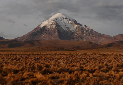
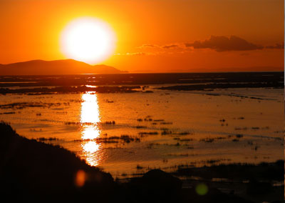
Bolivia's high plateau, or altiplano, is located between two major Andean mountain ranges, the Cordillera Occidental (Western range) and the Cordillera Oriental (Eastern range). The Cordillera Occidental chain has the highest peak of Bolivia and is a chain of dormant volcanoes and volcanic vents emitting sulfurous gases. Bolivia's highest peak, the snowcapped Nevado Sajama (6,542 m / 21,463 ft), is located here. The lower, eastern slopes of the Cordillera Oriental, known as the Yungas is a semi-tropical region of the country composed of forests. Rivers are plentiful in this region and drain into the Amazon Basin. The most prominent feature of the Altiplano is the largest lake of the country at its northern end, Lake Titicaca. The lake is 3,811 m (12,503 ft) above sea level and has a surface area of 9,064 sq km (3,500 sq miles). It is because of this lake that the climate of the nearby places remains moderate all through the year.
The valleys are another geographical feature that dominates the landforms of Bolivia. These valleys offer some of the most spectacular scenery in Bolivia. This region is also famous for its coffees and teas, fruit and flora, and of course, coca. Cochabamba (Bolivia's third largest city), Sucre (Bolivia's capital), and Tarija (home to Bolivia's world-famous wine country) are part of this lush valley geography and are sometimes referred to as the country's garden spots.
The Bolivian lowlands in the east, including the Chaco region, face semiarid conditions. Although forests cover nearly half of the country, the ample plains are used for cattle grazing and, in less inhabited regions, for coca cultivation.
Bolivia has more than 14,000 km (8,699 miles) of navigable rivers. The Beni, Chapare, Desaguadero, Guaporé, Mamoré, Paraguay, and Pilcomayo form the country's major waterways.
The culture
Bolivian culture has many Inca, Aymara and other indigenous influences in religion, music and clothing, depending upon the region of the country, isolation of the cultures and contact with European (Spanish) culture.
Very few aspects of Bolivia have changed over centuries. The country is fairly underdeveloped, with virgin forests, immaculate rivers and untouched countryside. Many indigenous groups have maintained their ancient cultures, languages and beliefs, and they still dress as they would have done hundreds of years ago.
Unfortunately, with this underdevelopment comes poverty. While travellers can revel in pristine forests and primary jungles, many Bolivians count as some of the poorest people in Latin America. They lean heavily on traditions and folklore and Mother Earth is as important to many as religion is. Shrines dedicated to her can be found all across the country. In return for their dedication, Mother Earth has provided a striking landscape across the country, with 10 national parks and eight protected areas. There are stunning lakes, imposing mountains and lush primary rainforest.
Festivals in Bolivia are generally pagan and are expressed by means of rituals and dances. Each village has a date set aside to celebrate their Saint also known as "Chicus Mass". After the mass, the parishioners go out in a procession. With the passing of time many changes have occurred. For example, the Oruro Carnival now opens with a "Folkloric Festival". Spectators enjoy a colorful parade of folkloric dances in devotion to the Socavon Virgin. Over the years dances styles change and the costumes are modified. Festivals in the east of Bolivia have more passive processions such as long walks. In the Chaco area, the festivals that take place are not accompanied by alcoholic beverages, a procession is carried out and regional products are sold, this practice is different from all the other festivals in Bolivia.
Many dances and songs contain elements from both the native and the Mediterranean culture. The dance of palla-palla or loco palla-palla, practiced by the Indians, symbolise the European invaders. The dance of Waka-tokoris of the Native Americans is a symbolic satire of the bullfights.
Bolivia's regional folk music is distinctive and varied. In the Andean regions, music is played during the festivals and dances. Some tunes contain strong Spanish influences.
The Bolivians food consist of meat dishes, rice , potatoes and shredded lettuce and various hot sauces made from tomatoes and lettuce are used. Bolivia culture of food is a mix of great cuisines with good drinks and along with bear and wine, "chicha" a drink made from maize liquor is used.
Attractions & landmarks
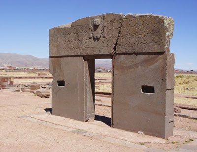
Bolivia is home to the largest statue of Christ in the world, the Cristo de la Concordia (Christ of Peace) in Cochabamba. The height of this landmark is 33 m (108 ft), since Christ was 33 years old when he died. Here visitors will also find the Copacabana Cathedral, one of the oldest churches in Bolivia and a fine example of Moorish style architecture. It was completed in 1619, and houses the statue of La Virgen de la Candelaria (also called the "Dark Virgin"), which is reputed to have miraculous healing powers. Near Copacabana is Lake Titicaca, one of the most beautiful and much respected sacred lake that lies on the border between Peru and Bolivia. According to Incan mythology, it was from Lake Titicaca that the creator god Viracoca rose up to create the sun, moon, stars, and first human beings. Recently, a large temple was discovered submerged in the lake, adding to its mystery and fascination. Located near Lake Titicaca is the mysterious Gate of the Sun (Puerta del Sol), a famous megalithic solid stone arch or gateway constructed by the ancient Tiwanaku culture, a civilization that surfaced around 600 BC and mysteriously disappeared around AD 1200. It is approximately 3 m (9.8 ft) tall and 4 m (13 ft) wide, and is constructed from a single piece of stone. The structure is considered an icon of the Bolivian National identity and is believed by archaeologists to be associated in some way with the sun god, and was perhaps used as a calendar.
Sucre is the symbolic heart of the nation. It was here that independence was proclaimed, and while La Paz is now the seat of government and treasury, Sucre is still Bolivia's judicial capital. Sucre has many historical buildings with the Casa de la Libertad having the most significance. It was here, on the 6th of August 1925, when Bolivia signed its Declaration of Independence from Spain, drafted its first Constitution and laws, and named Sucre, its first city, the capital of Bolivia. In addition, the Museo de la Recoleta was historically used as a barracks, prison and a convent, which is now home to a huge art collection.
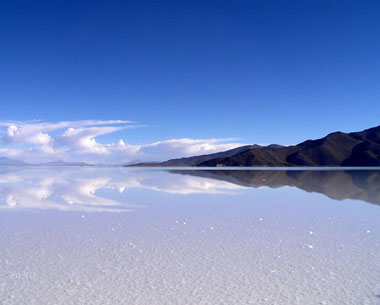
In South-west Bolivia is Potosí, one of the highest cities in the world by elevation at 4,090 m (13,420 ft). It was founded in 1546 after the discovery of the rich silver deposits in the Cerro Rico, which was soon bankrolling the Spanish empire. The mines of the Cerro Rico are the richest mines in all of world history and may have produced 60,000 tons of silver. The wealthy history of Potosí is still reflected in the narrow streets, colonial mansions and the many churches. Also located here is Salar de Uyuni, the world's largest salt desert which can be viewed as Earth's brightest spot from space. It comprises over 10,000 sq km (6,213 sq miles) of completely flat expanse of dry salt which is 10 m (32 ft) thick in the center.